Conservation Park
Announcement(s)
Due to the recent hurricanes, the Rocky Creek bridge portion and the area between Sheldon Road and the Wilsky Trailhead remain closed. (Updated 11/27/24)
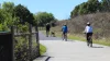
The Upper Tampa Bay Trail (UTBT) is located in residential northwest Hillsborough County. Currently, the trail runs along the west shore of Channel A from a trailhead off Memorial Highway/Montague Street, past Waters Avenue, Linebaugh, and then due north to Gunn Highway, Ehrlich Road and ending at Peterson Road Park.
The trail continues north from Van Dyke Road north and then east to the trailhead on Lutz Lake Fern Road, connecting to the Suncoast Trail at the Veterans Expressway.
Trailheads and access south to north
We have six trailheads or access points for UTBT.
Memorial Trailhead: 7499 Montague Street
- Cold water and parking
- Directions: Take Hillsborough Ave. west past the airport, Memorial Highway and Sheldon Road. Turn right on Montague Street. Follow Montague to the trailhead a short distance on the right.
Channel Park Trailhead: 9201 W. Waters Avenue
- Restrooms, parking, water and drink machines
- Directions: Hillsborough Ave. West to Sheldon Road. Turn Right (north) onto Sheldon Road to Waters Ave. Turn left (west) onto Waters Ave. The trailhead is a very short distance on the right.
Wilsky Boulevard Trailhead: 10314 Wilsky Blvd.
- Parking, cold water and restrooms
- Directions: From Tampa, take Waters Ave west to Hanley Ave. Head north on Hanley Ave, Hanley becomes Wilsky Blvd at Linebaugh. Cross Linebaugh, the trailhead is on the left/west side of Wilsky Blvd., before the on ramp to the Veterans Expressway.
Ehrlich Road
- Parking, water, map
- Directions: From Tampa, take Ehrlich Road west toward Gunn Highway. The trail parking area is just east of Gunn Highway, south of Ehrlich, and adjacent to an old house. It is not directly on the trail and could be easily missed. The trail is two houses to the west, just before the intersection, next to Bally Hoo Restaurant. The water cooler and map are just south of the parking along the trail.
Peterson Park: 8203 Peterson Road and Rails Road
- Parking, restrooms
- Directions: From Tampa take Gunn Highway north. Peterson Road is a mile north of the Gunn Highway/Sheldon Rd intersection at Sickles High School. Turn right onto Peterson Road. The park and the northern terminus of the trail are located ½ mile on the left.
Lutz Lake Fern Trailhead: 7020 Lutz Lake Fern Road
- Parking, restrooms, and directions: On the south side of Lutz Lake Fern Road east of Gunn Highway and west of the Veterans Expressway.
Upper Tampa Bay Trail Rocky Creek bridge replacement project
Frequently asked questions and information about the project.
Why is the bridge closed?
- During a recent annual inspection by Hillsborough County engineers, the Rocky Creek Bridge was deemed unsafe and closed unexpectedly in February 2024
- The Rocky Creek Bridge was scheduled for replacement beginning in late 2024, with completion in late 2025, which would have resulted in about a one-year closure
Background
- The trail was built along a defunct railroad route
- Originally constructed as part of the Tarpon Junction railroad spur, the estimated date of the Rocky Creek Bridge construction is 1913, which makes the wooden structure 111 years old
- Repairs were made in 2016 to extend its life, with the expectation that the bridge would be replaced in the future
What’s open?
- The closure creates two similar-length trails to the north and south of the closed bridge
- A trail about 4 miles long is open from Old Memorial Highway Trailhead north to the closure
- A trail more than 3 miles long is open from Peterson Road Trailhead south to the closure
- Hillsborough County also has several other cycling and walking trails from which to choose
The new bridge
- The new bridge will have two spans and be 126 feet in length, with a reinforced concrete deck
- The proposed pedestrian bridge will match the width of the existing 12-foot trail
- It will be ADA compliant and be able to accommodate emergency vehicles if necessary
